Leveraging the technology behind its existing suite of satellite imagery products and its expertise in artificial intelligence, search-engine giant Google (Mountain View, California) is pursuing new ways to help people protect life and property in the event of major floods.
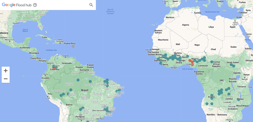
This month, Google unveiled FloodHub, a publicly accessible portal that enables users to detect riverine flooding up to a week in advance at parcel-scale resolution, showing precisely where rivers likely will overflow as well as how much flooding locals can expect. The technical work underpinning FloodHub has been underway since 2018, the company writes, beginning with coverage of India and Bangladesh and gradually scaling up to more countries. Today, FloodHub offers ongoing forecasts in 20 countries across Africa, Southeast Asia, and South America, with a goal to extend coverage worldwide, writes Yossi Matias, head of Google’s Crisis Response team.
“This expansion in geographic coverage is possible thanks to our recent breakthroughs in AI-based flood forecasting models,” Matias describes. “We’re committed to expanding to more countries.”
Forecasting With FloodHub
When Google formed partnerships with the Indian Central Water Commission and Bangladesh Water Development Board in 2018, the company sought to demonstrate that a machine-learning program trained on local river gauges could provide proactive and actionable flooding information to those living along the region’s major rivers. The product of this early work was a smartphone-based notification system that would give advance warning to any device with either Google Search or Google Maps installed if the program expected flooding based on shifting water levels and historical patterns.
In 2021, according to Matias, this notification system delivered 115 million flood alert notifications to 23 million people in India and Bangladesh. It also informed on-the-ground outreach efforts by community groups to those living in the region without Google-accessible devices.

However, the program’s reliance on river gauges not only limited the range of rivers on which it could be applied, but also provided only a maximum of 2-3 days of advance notice to locals. In recent years, Google describes, machine learning has become sophisticated enough to make functional, parcel-scale predictions incorporating weather forecasts in addition to river-gauge readings. In an August study about the new machine-learning approach at the foundation of FloodHub, Google researchers describe how incorporating weather forecasts from such sources as the U.S. National Aeronautics and Space Administration (NASA) and U.S. National Oceanic and Atmospheric Administration (NOAA) can yield accurate flood predictions up to a week in advance of a river overflow event as well as more reliably assess threats for river basins without expansive gauge networks.
With FloodHub, Google’s notification system has evolved into a visual and interactive format, appearing as an overlay of data gleaned from its machine-learning program on top of its popular Google Earth interface. At a glance, users can identify regions where flooding is likely according to a color-coded system of severity. They can then zoom in for more details on specific areas at risk and the likely timing of the event.
Data-Driven Stormwater Control
Other recent work by Google in the field of stormwater management has applied machine learning to disaster response after hurricanes as well as green infrastructure implementation.
In 2020, Google partnered with the United Nations World Food Program to introduce a new way to assess damages and prioritize relief efforts after a hurricane by using machine learning to quickly interpret satellite imagery. Particularly when hurricanes cause damages over a large area, disaster response professionals often undertake a manual process to pore through thousands of satellite images to assess the areas hit hardest, a process that typically takes days to complete. Google’s system, by contrast, analyzes satellite images to detect the boundaries of each specific property within a damaged area and compare the post-hurricane state of each parcel against the most recent pre-hurricane image available. It then applies an algorithm to determine which areas require the most urgent assistance, accelerating response times. As reported by Wired, the program was recently deployed in Florida in the wake of Hurricane Ian, where it helped aid groups coordinate relief payments.
While launching FloodHub, Google also announced plans to improve on its existing Tree Canopy Insights app. The app, based on the Google Earth engine, provides a neighborhood-by-neighborhood overlook of tree canopy coverage in 14 U.S. cities, offering this information alongside local climatic and socioeconomic data. By providing an accessible connection between canopy coverage and such factors as surface temperatures, population density, and median household income, the app aims to help urban planners pinpoint areas where planting new trees can make the most significant differences in residents’ quality of life, Matias describes. By the end of 2022, Google intends to expand the app’s coverage to “hundreds of cities,” the company announced in November.
Top image courtesy of PIRO/Pixabay

ABOUT THE AUTHOR
Justin Jacques is editor of Stormwater Report and a staff member of the Water Environment Federation (WEF). In addition to writing for WEF’s online publications, he also contributes to Water Environment & Technology magazine. Contact him at jjacques@wef.org.


