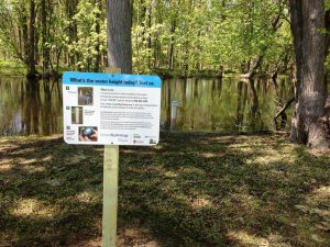
Each CrowdHydrology study site contains a measuring stick planted at the bottom of a waterway that acts as a stream gauge. Each site also features an educational sign that instructs passersby how to read the gauge and submit measurements via text message. Photo courtesy CrowdHydrology
In 2010, a smartphone-based campaign that called on motorists to report roadkill sightings in California via text message inspired University of Buffalo (UB; N.Y.) hydrogeologist Chris Lowry to undertake an experiment. If it didn’t require any prior knowledge or specialized equipment besides the small computers we carry in our pockets, could ordinary people help gather scientifically significant data about rivers and other waterways?
That was the question behind CrowdHydrology, which began when Lowry planted a measuring stick at the bottom of a pond in Wyoming County, N.Y., next to a sign with his phone number on it. The sign asked recreationalists to read the most current stream-stage measurement and text Lowry a number, to be used alongside other observations to predict such conditions as drought and flooding before they occur.
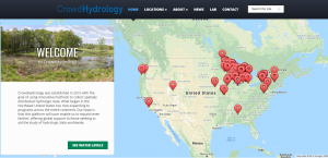
Now in its eighth year of data collection, CrowdHydrology has established dozens of observation stations in waterways across 14 U.S. states. And thanks to a new multidisciplinary partnership funded by the U.S. National Science Foundation (NSF), data from CrowdHydrology will soon be part of the U.S. National Oceanic and Atmospheric Administration (NOAA) National Water Model.
Better flood predictions through crowdsourcing
The NOAA National Water Model is an advanced computer simulation that draws on data from USGS, the U.S. National Center for Atmospheric Research (NCAR), and other sources to model and forecast streamflow conditions in waterways throughout the entire continental U.S. To do that, the model assigns mathematical values to each stage of the water cycle as well as the short- and long-term effects of storms.
UB received US$90,000 from NSF to use data from CrowdHydrology to “develop new quality control and data assimilation methods” to improve the National Water Model’s predictions, according to a UB release.
“I spent the summer down in Alabama working with scientists at NOAA’s National Water Center to look at ways we could use citizen science data to help improve the model,” Lowry told UB.
The grant is part of a larger NSF initiative that aims to use image recognition technology to harvest crowdsourced data from unconventional sources — for example, social media posts, traffic camera footage, and webcam streams. These data will be used to provide better warnings for citizens and first responders when flooding is expected in their area. In October, NSF awarded a total of $1.5 million under the initiative to UB, Arizona State University (ASU; Tempe), Northern Arizona University (Flagstaff), the University of Arizona (Tucson), and Michigan Technological University (Houghton).
The collaboration, which includes engineers, hydrologists, and computer scientists, will aim to create a flood-warning system that uses 21st-century communication and information technology to emphasize speed and accessibility, said principal investigator and ASU researcher Mikhail Chester.
“The prevalence of smartphones and webcams create new opportunities that haven’t existed to provide insights into what’s happening in the world around us,” Chester said. “We want to put those technologies in the hands of communities to protect themselves against extreme events.”
Citizen science gains traction in the water sector
CrowdHydrology’s inclusion in the NSF initiative provides an answer to Lowry’s question about the integrity of citizen science data.
“Early on, many scientists told us they thought citizen science data is of low quality,” Lowry said. “We have worked hard to show the science community that these data are not only accurate but useful. It is wonderful to see CrowdHydrology being used in this big, multi-institutional research project.”
CrowdHydrology, founded in 2010, is a crowdsourced data-gathering campaign that calls on the public to report water levels in streams and ponds of interest as they fluctuate with local hydrological conditions. The platform has expanded to solicit data from dozens of waterways in 14 U.S. states. Photo courtesy CrowdHydrology
In 2018, the platform passed 8000 users, Lowry said. Its busiest stream gauge stations attract more than 300 measurements each year. All the data collected from these stations are available free-of-charge to the public.
CrowdHydrology is one of several successful citizen science projects in the water sector. For example, an NSF-funded pilot project called Off the Roof is asking households across the U.S. to collect runoff samples from their roofs after rainstorms to inform potential regulations around stormwater reuse. As efforts to improve the water quality of the Chesapeake Bay continue to yield results, a project based at the University of Maryland (College Park) called DolphinWatch calls on shore-dwellers to help track summer dolphin sightings. Each project relies on crowdsourced data to advance the ways hydrologists monitor, improve, and interact with the water environment.
“Without these engaged citizen scientists, none of this would be possible,” Lowry said.
Find a CrowdHydrology observation station near you and browse data points at www.crowdhydrology.com.