Accurately estimating the arrival time of a plane, train, or bus requires a few key details, such as its location and speed at a given point. The same basic principles guide meteorologists as they predict when storms will make landfall. However, in the case of atmospheric river (AR) storms — long, narrow bands of highly concentrated water vapor that deliver immense amounts of precipitation to the Western U.S. — such typical instruments as weather satellites and barometers often fail to provide information detailed enough to make actionable predictions about where AR storms will occur or how much precipitation they will deliver.
For that reason, researchers are teaming up with pilots to get an up-close look at ARs as they form over the Pacific Ocean. AR Recon, a joint initiative led by UC San Diego’s Center for Western Weather and Water Extremes (CW3E), the U.S. National Oceanic and Atmospheric Administration (NOAA), and the U.S. Air Force Reserve, began its eighth seasonal monitoring campaign in November.
Through March 2024, the AR Recon program will undertake dozens of flights into the core of developing AR systems aboard specialized aircraft. Crews will gather extensive data to help meteorologists better track the path of these systems as they near the U.S. coastline, inform reservoir operations, and plan flood-management efforts.
“The AR Recon program fills a big information gap over the Pacific Ocean where these atmospheric rivers form,” said Marty Ralph, Research Meteorologist and CW3E Director, in a statement. “Climate models suggest atmospheric rivers are only going to become more important as hazards and as water sources, making efforts like ours to better forecast and understand them an essential facet of adapting to our world’s changing climate.”
Expanding the Itinerary
The first AR Recon flights began in 2016 as part of NOAA’s El Niño Rapid Response campaign, which sought to use the U.S. Air Force’s C-130 Hercules aircraft to monitor movements of the El Niño system south of Hawaii. El Niño conditions are closely associated with AR systems, accelerating the North Pacific storm track and increasing the likelihood that an AR system will surge toward Southern California.

The C-130 aircraft, outfitted with state-of-the-art monitoring equipment and built to withstand the stresses of flying through extreme weather, captured high-resolution information about the weather systems that led to a spate of AR storms that arrived in California in February 2016.
Encouraged by the improved predictions the data gathered during these six initial flights enabled, AR Recon partners launched a scaled-up version of the program in 2018. This iteration included additional flights by NOAA’s similarly built Gulfstream IV aircraft, which allowed the total number of flights to increase to 13 as well as launch from both California and Hawaii.
Following a period of steady growth, AR Recon crews undertook a record-high 51 flights during the 2022–2023 monitoring campaign. Using the data from these flights, meteorologists showed more than a 10% improvement in accurately predicting, at least 3 days in advance, when an AR system would make landfall on the U.S. West Coast. The AR Recon team contends that this increase is not expected from conventional forecast models, which gradually improve their prediction abilities based on data gleaned from new AR storms via satellites and other long-distance equipment, for roughly another decade.
The 2023–2024 season is poised to be AR Recon’s most extensive monitoring campaign yet. For the first time, flights will launch from Guam — nearly 10,000 km (6,200 mi) west of California — during a 2-week period in early January. Tracking AR systems that form this far away carries the potential to grant forecasters even earlier notice of approaching storms.
“Atmospheric rivers usually move from west to east in the Pacific,” Ralph said. “The farther west we can go in collecting observations, the greater potential we have for improving the lead time in our forecasts.”
A Land, Air, and Sea Approach
The work of each AR Recon flight begins well in advance of when it achieves liftoff.
CW3E researchers, working closely with NOAA’s Environmental Modeling Center, the U.S. Army Corps of Engineers, the California Department of Water Resources, and other partners, precisely plot the path of each flight so that it will gather the most actionable data possible. This process begins by using conventional storm-forecasting models to estimate the core, or center, of AR systems as they form. Expert meteorologists then consider the effects of such significant atmospheric features as upper-level jets and cold-air troughs to infer how the core will move over time, before identifying a flight path that will enable the aircraft to follow it.
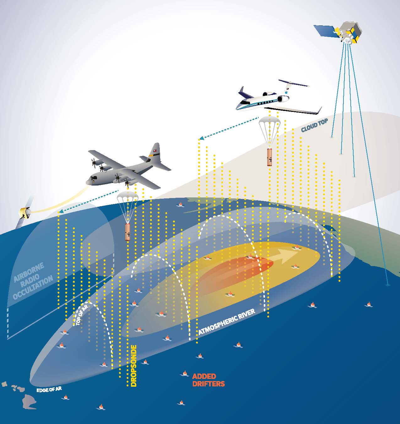
Once in place either above or within the core of the AR system, the aircraft will deploy a series of instruments called dropsondes. These small, cylindrical sensors are fitted with parachutes that send them drifting slowly toward the ocean, transmitting detailed information about air temperature, pressure, water vapor, and wind speed in real time as they descend. Additionally, this year’s aircraft also will be equipped with airborne radio occultation (ARO) sensors — an experimental approach pioneered by UC San Diego researchers that uses delays in signals from GPS satellites to assess fine-scale atmospheric conditions. These ARO sensors can provide near-constant atmospheric measurements from up to 300 km (186 mi) from the sides of the aircraft as it flies, supplementing data from the dropsondes.
However, airborne measures are only one piece of AR Recon’s multipronged monitoring strategy. Through the NOAA-led Global Drifter Program, AR Recon also draws on data from a series of ocean buoys outfitted with atmospheric pressure sensors. This season’s campaign will benefit from more than 80 new Global Drifter buoys that will help researchers track surface-level conditions based on the movement of AR systems.
Land-based measurements, such as those provided by weather balloons launched along the West Coast, complete the suite of AR Recon sensors. Mirroring the function of dropsondes, these weather balloons ascend up to 35,000 m (115,000 ft) from ground level and often drift more than 160 km (100 mi) away from their launch site, transmitting similar information about near-shore atmospheric conditions. Ahead of this season’s campaign, AR Recon established two new weather balloon launch sites in coastal Washington and upgraded five existing sites along the California coastline.
Top image courtesy of Jessica Kendziorek/U.S. Air Force

ABOUT THE AUTHOR
Justin Jacques is editor of Stormwater Report and a staff member of the Water Environment Federation (WEF). In addition to writing for WEF’s online publications, he also contributes to Water Environment & Technology magazine. Contact him at jjacques@wef.org.