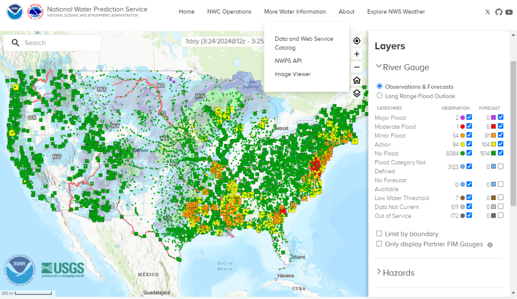
The U.S. National Oceanic and Atmospheric Administration (NOAA) has unveiled a new website as a centralized gateway to its ever-expanding library of water data and forecast information.
Launched on March 27, NOAA’s National Water Prediction Service (NWPS) platform merges information from the Advanced Hydrologic Prediction Service (AHPS) and NOAA’s Office of Water Prediction. Its primary objective is to empower users, including stormwater professionals and engineers, in making informed decisions regarding water-related matters. New features represented in NWPS include real-time river observations and forecasts, present and future precipitation estimates, and geographical representations of areas experiencing flood warnings, watches, and advisories.
“By centralizing and fully integrating the dissemination of NWS hydrologic data, NWPS will become the gateway to NWS water information and will provide communities nationwide with access to essential water data, forecasts and support services,” said Michael Musher, NWS Public Affairs Specialist.
Old Technology Eclipsed
The U.S. National Weather Service (NWS), part of NOAA, has hosted river forecast data on its AHPS webpage for more than 20 years. However, Musher describes that AHPS lacked the ability to incorporate new tools and technologies essential for addressing the escalating challenges posed by flooding, droughts, and water availability.

NWPS will function as a comprehensive solution to bridge this gap, providing a user-friendly hub for up-to-date information and equipping water managers, researchers, forecasters, and other users with the resources necessary to navigate complex water management issues with confidence. Its data spans the entire United States as well as its territories.
Previous hydrographs provided by AHPS and the Office of Water Prediction detailed river-gauge and precipitation data only within the previous 72 hours. The new tool shows observations within the previous 30 days. It also offers river-stage predictions as much as 7 days in advance, improving on the capabilities of previous tools.
“NWS is taking a major step in the modernization of its infrastructure and dissemination capabilities with the implementation of the new, cloud-hosted National Water Prediction Service to better serve its core partners and the public before, during, and after extreme water events, and to better inform routine water management decisions,” Musher said.
Incorporating Climate Change Variables
NOAA is working to integrate findings from Atlas 14, which offers regional estimates of rainfall depth, duration, and frequency for nearly the entire United States, into the new NWPS tool. Additionally, with funding from the 2021 Bipartisan Infrastructure Law, NOAA will develop and incorporate the updated Atlas 15.
Atlas 15 will interpret temporal trends in historical observations, create future climate model projections based on those historical observations while accounting for climate change, and develop precipitation frequency estimates for the United States and its territories. The first iterations of Atlas 15 are anticipated to be completed and functional in 2027.
Additional features of the new NWPS resource include:
- analysis of current snowpack contents, representing both snow depth and snow water equivalent;
- an experimental flood-inundation map layer, which represents the NWS’ best approximation of inundation extents based on modeled river discharge; and
- the ability to visualize administrative boundaries alongside hydrological information.
A user’s guide highlighting key features is available here.
Top image courtesy of Michael Kleinsasser/Pixabay

ABOUT THE AUTHOR
Michelle Kuester is a staff member of the Water Environment Federation, where she serves as Associate Editor of Stormwater Report and Water Environment & Technology magazine. She can be reached at mkuester@wef.org.


