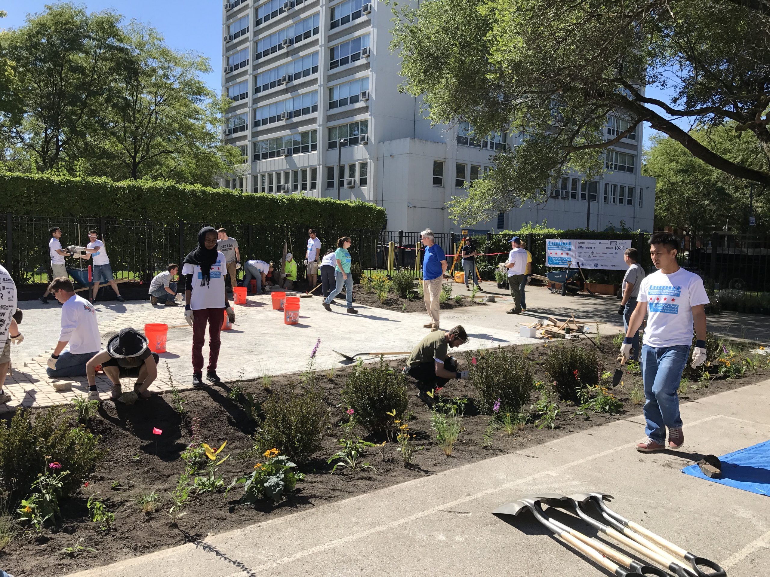
Part of the challenge of achieving financial and social buy-in for flood management projects is that their benefits often only become apparent when flooding does not occur. Without the ability to demonstrate, for example, how investment in flood control by public officials can minimize future disasters or how taking simple mitigation steps can help homeowners protect their property in ways they can see, hear, and feel, many may regard stormwater investment as a commodity rather than a necessity.
Universities, government agencies, and environmental organizations are embracing technology to create a new form of public outreach for the stormwater sector. Through interactive simulations, homeowners and financial decision-makers can experience the real-world benefits of flood-mitigation projects – as well as the potential costs of inaction – without risking lives and property.
Storm Surge Hits Home
While storm surge is a major cause of coastal flooding, coastal property owners might not understand their potential exposure to storm surge as clearly as to rainfall or wind speed during heavy storms. Because storm-surge severity relies on complex factors such as ocean-floor topography and the storm’s angle of approach, estimating how potential storm surges might affect specific properties is a difficult proposition for coastal residents.
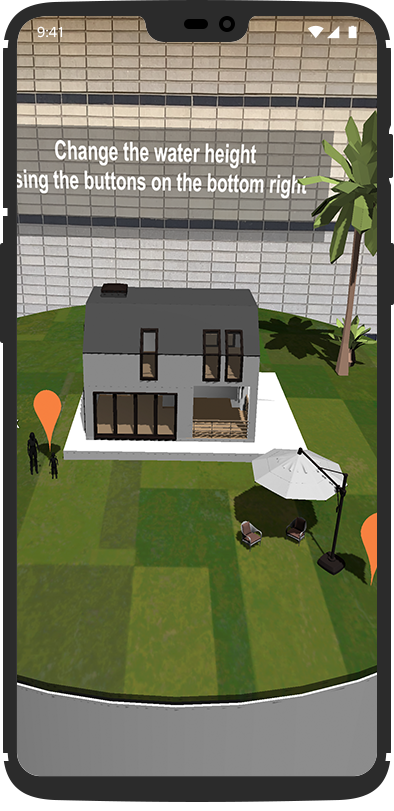
Offering homeowners multiple ways to assess their property’s vulnerability to storm surge is the goal of a new, smartphone-based app developed by researchers from the University Corporation for Atmospheric Research (UCAR; Boulder, Colorado). The app, called Storm Surge AR, uses a device’s camera and location to enable users to superimpose floodwaters from various levels of storm surge directly onto their surroundings.
“When you see your house underwater, it creates an emotional reaction,” Tsvetomir Ross-Lazarov, UCAR researcher and the app’s lead designer, said in a statement. “It’s not just theoretical possibilities anymore. You can visualize the real impacts.”
Within the simulation, users can learn about sandbags and the level of sandbag deployment necessary to mitigate flood effects at different severities. Additionally, the app uses data from the National Weather Service to render a bird’s-eye view of how different levels of storm surge would affect a user’s region, identifies local evacuation routes, and provides educational materials to help users better understand storm surge.
Storm Surge AR is available for free on Google Play and the iOS App Store.
In Their Shoes
Pre-emptive investment in flood-control infrastructure makes a crucial difference while managing and recovering from a storm-related crisis.
To convey that message to the public officials who make funding decisions, the U.S. Federal Emergency Management Agency (FEMA) created Immersed, a virtual simulation that puts users in the shoes of a crisis-management professional as they facilitate evacuations and rescue trapped civilians during a major flood event. FEMA brings the Immersed simulation, which requires a specialized virtual-reality headset, headphones, and a handheld controller, to meetings and conventions.
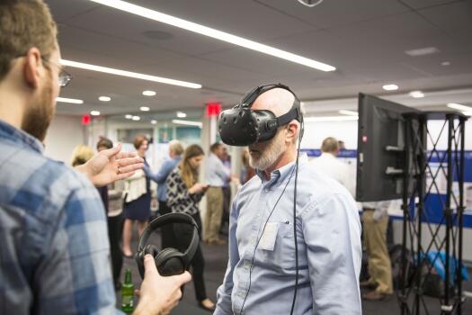
Immersed features three distinct scenarios: one in which the player directs traffic at a major evacuation route impaired by floodwaters, another that takes place in a flooded school where users must locate and rescue a stranded teacher, and a third in which a slowly sinking residential neighborhood weathers a major storm. Depending on the scenario, the player’s handheld controller becomes tools — such as a flashlight, a clipboard, or a traffic cone — which directly affect the simulation.
In real-time, each scenario shows how the crisis becomes easier to manage with proper infrastructure in place. For example, while traffic might grind to a standstill after an evacuation route unserved by stormwater infrastructure becomes inundated, installing larger culverts along the roadway keeps vehicles moving, making the player’s job of directing traffic far easier. At the school, power outages make the job of locating the trapped teacher far more difficult; but by elevating the school’s generator above the flood threshold, the lights stay on.
Peter Herrick of the FEMA Flood Insurance and Mitigation Administration described in a 2018 episode of The FEMA Podcast that Immersed creates an emotional connection to flood-management infrastructure that data alone cannot.
“What we wanted to do is have people get that visceral reaction, really feel what it’s like to go through a flood, and see for themselves what the damages are and how they can mitigate against that risk,” Herrick said.
The Green Infrastructure Game
Environmental advocates with Earthwatch Europe (EE; Oxford, England) demonstrate that virtual experiences can be used to educate about flood mitigation as well as to garner support for other stormwater priorities, such as green infrastructure adoption.
EE brings its simulation, which features a two-dimensional map of a hypothetical city, to conventions focused on urban planning, climate change, and stormwater management. When users aim a tablet camera at the map, the camera renders an interactive, three-dimensional model of the city, and options appear that enable users to add combinations of several types of green infrastructure.
Players can interact with the model in two ways. First, they can learn about how interventions such as manmade lakes, rain gardens, and green roofs can work together to address complex environmental issues. Second, the simulation can ask users which types of green infrastructure they would deploy to help mitigate a particular problem, such as nuisance flooding or the urban heat-island effect.
As users strategically add green infrastructure to the model, the appearance of the city changes in real time, and a host of information about the chosen combination appears that helps acquaint users with green infrastructure co-benefits. Multiple users can interface with the city at the same time, creating opportunities to compare strategies and spur conversations about the value of green infrastructure.
“This experience focuses on actions which those working in the built-environment sector — such as local authorities, planners, architects, landscapers, builders, and policymakers — could take to create more sustainable cities,” said Victor Beumer, EE senior research lead, in a statement. “Augmented reality is an exciting technology and is a fun and memorable way to bring alive the science of nature-based solutions and the benefits they can bring to cities.”
Watch a video about the simulation from EE’s development partner, Atticus Digital (Cardiff, Wales), below: