As much of the world enters its annual hurricane season, a new resource is providing information about how severe storms develop, move, and deliver precipitation. The U.S. National Aeronautics and Space Administration (NASA) coordinated a newly launched satellite surveillance mission to collect this data.
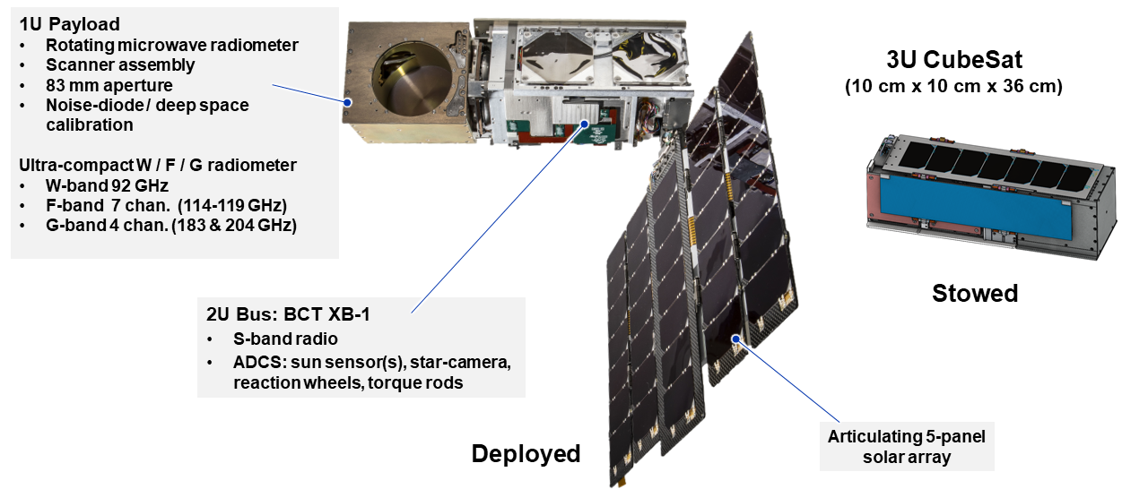
NASA launched the Time-Resolved Observations of Precipitation structure and storm Intensity with a Constellation of Smallsats (TROPICS) mission in May. The mission involves a “constellation” of four strategically positioned satellites — each roughly the size of a milk carton — capable of monitoring atmospheric conditions throughout Earth’s tropical regions more frequently and in greater detail than existing surveillance techniques.
The team behind the mission represented the Massachusetts Institute of Technology (MIT; Cambridge), U.S. National Oceanic and Atmospheric Administration (NOAA), Rocket Lab USA, Inc. (Long Beach, California), and other partners. They hope new information gleaned from TROPICS will help improve forecasting capabilities for intense storms.
“As communities throughout the world are experiencing the growing impacts of increased extreme weather, it’s never been more important to get timely data to those who need it most to save livelihoods and lives,” said NASA Administrator Bill Nelson in a July release. “TROPICS will deliver vital information for forecasters, helping us all better prepare for hurricanes and tropical storms.”
More Frequent and Comprehensive Snapshots
TROPICS is not the first satellite mission intended to study how storms form, but the project team describes that it will greatly improve the quantity and quality of such observations.
Existing monitoring capabilities enable orbiting satellites to take a snapshot of a single point in Earth’s troposphere about once every 6 hours. By deploying multiple satellites, each with its own travel path, that interval shrinks to roughly 1 hour. The difference will provide researchers with a far more complete picture of how storms gradually evolve from minor cloud accumulations to hurricanes and typhoons.
“Providing more frequent imaging will not only improve our situational awareness when a hurricane forms, the data will provide information to models that help us determine how a storm is changing over time,” said Karen St. Germain, Director of NASA’s Earth Science Division, in a release. This information “in turn helps to improve forecasts from our partners like the National Hurricane Center and Joint Typhoon Warning Center.”
At a low-Earth orbit altitude of about 550 km (340 mi) above the planet’s surface, the four TROPICS satellites are far closer to the region of the atmosphere where weather patterns occur than previous satellite missions. This is possible, in part, to the satellites’ small size. Each of these solar-powered satellites features a full retinue of monitoring equipment, such as high-performance, quickly rotating radiometers as well as various sensors that measure such factors as air temperature, concentration of ice and water vapor in clouds, and precipitation speeds and volumes. The satellites’ positioning, as well as the specific angles at which they orbit the Earth, maximize their monitoring coverage over both time and distance to provide high-frequency imagery of storm behavior across virtually all of Earth’s tropical regions.
According to the mission’s website, each satellite was designed to orbit reliably without maintenance for about 9 years. However, the current satellites will orbit Earth for a trial period of 1 year for the purposes of the TROPICS mission.
Already Delivering Results
The TROPICS mission transmitted observations of its first named tropical storms in June.
From the morning of June 28 through the afternoon of June 29, TROPICS satellites captured more than 20 detailed snapshots of storm clouds off the west coast of Mexico, detailing how the clouds gradually accumulated into what became Hurricane Adrian. At the same time, the satellites also captured the development of Hurricane Beatriz slightly further north.
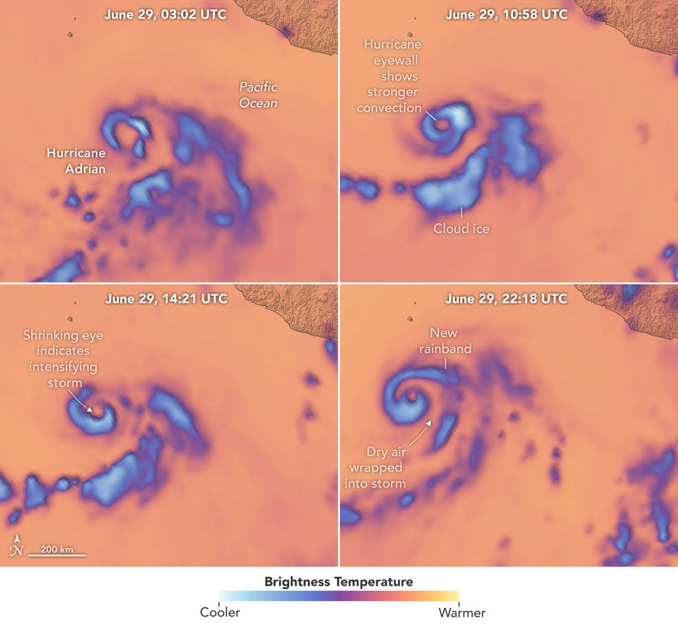
The images provided by TROPICS satellites contain 12 distinct types of data, each of which helps forecasters and researchers understand different aspects of how tropical storms behave. One data channel represented in imagery is “brightness temperature,” from which researchers can derive the amount of ice entrained in clouds at a given time. Lower brightness temperatures translate to higher ice concentrations, which in turn helps inform a more detailed picture of convective forces that drive storms to occur.
Using this data, researchers can identify the location of rain bands as well as if the storm has formed an eye. This information is crucial for NOAA, the U.S. Joint Typhoon Warning Center, and other tropical storm-focused agencies as they determine where and when intense storms may make landfall.
“As we move into hurricane season for 2023, TROPICS will be in position to provide unprecedented detail on these storms, helping us better understand how they form, intensify, and move across the ocean,” St. Germain said. “We rely on targeted, innovative missions like this to help create a robust Earth science portfolio.”
Learn more about NASA’s TROPICS mission at its website.
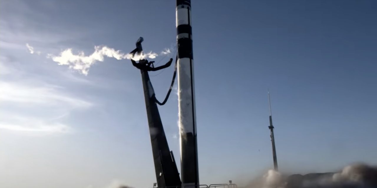
Top image courtesy of Rocket Lab USA, Inc.

ABOUT THE AUTHOR
Justin Jacques is editor of Stormwater Report and a staff member of the Water Environment Federation (WEF). In addition to writing for WEF’s online publications, he also contributes to Water Environment & Technology magazine. Contact him at jjacques@wef.org.