A new agricultural conservation planning framework (ACPF) will provide a systematic approach to identifying the best options for reducing nutrient losses and erosion within a watershed. The research, led by the U.S. Department of Agriculture’s Agricultural Research Service (USDA-ARS) and the Environmental Defense Fund, will address the growing need for agriculturalists to improve water quality, curb erosion, and meet other environmental goals as well as target soil and water conservation practices. The April issue of the Journal of Environmental Quality contains the full research article.
Most attempts at precision conservation — selecting the right conservation practice and placing it where it will be most effective — focus on one practice at a time. However, the ACPF looks at several. The result is an entire inventory of conservation possibilities to choose from and strategize with. The ACPF results are not prescriptive but are meant to spark discussion and collaboration. Additionally, the ACPF looks at whether practices can be placed in sequence, rather than depending only on a single approach to improve water quality.
ACPF efforts began in 2012 with researchers creating criteria for siting conservation practices in a suite of optimal locations within a watershed. The criteria are based on such information as soil type, land use, and the presence of tile drainage. Researchers also used extremely detailed, topographic maps derived from LiDAR surveys of the ground surface. The resolution is so fine that even the height of stream banks can be estimated.
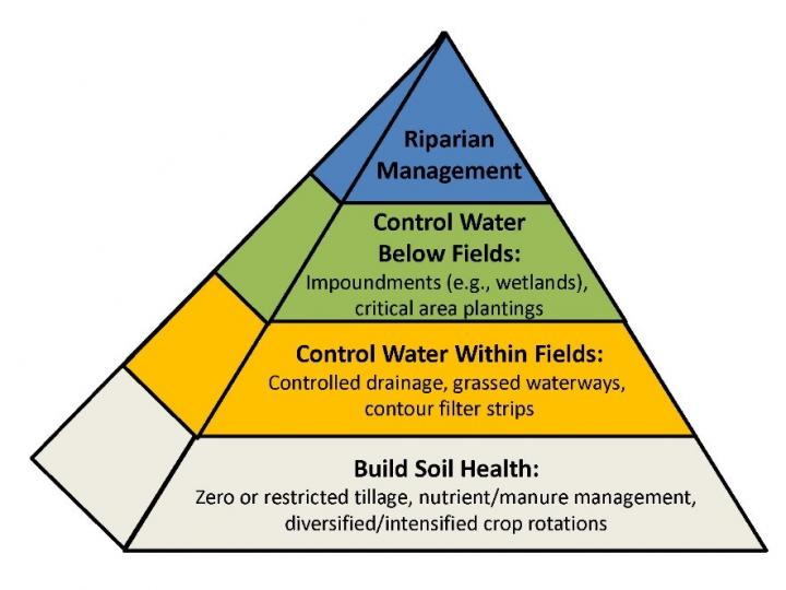
This image shows conservation planning in a watershed conceptualized as a pyramid. At the base are fundamental practices to improve soil health, such as crop rotations. These practices are then built upon by techniques that control water flows and nutrient losses within fields, outside of fields, and finally along stream corridors. Figure courtesy of Tomer, M.D, et al. 2013.
The siting criteria informs the framework, which is basically a pyramid with cover crops and other crucial soil management practices at its base. The next level focuses on options for reducing runoff and nutrient losses within farm fields. This level of the framework helps to answer which fields, for example, are most suited to controlled drainage systems or grassed waterways.
Next, the ACPF pinpoints the prime areas for conservation practices outside of fields — nutrient removal wetlands, for instance. And, lastly, it identifies the prospects for reducing both surface and subsurface losses of nutrients and sediments along stream and river corridors.
“You can think of it as a continuum of opportunities,” said lead author Mark Tomer, a USDA-ARS scientist in Iowa. The framework starts with essential soil health practices that every farmer wants to use, and moves up to more specialized, and sometimes more expensive, technologies that should be installed only where they will provide the most benefit.
Users also can calculate how much cropland will need to be taken out of production to make room for conservation installations. Researchers examined different scenarios to determine how many farm acres would need to be sacrificed to meet their chosen water quality target, which is the Iowa Nutrient Reduction Strategy goal of a 40% drop in nitrogen. In two test watersheds in Iowa and Illinois, researchers found the target could be met feasibly at the expense of just 3% to 4% of total cropland. Read the first open-access paper about the ACPF here and the second paper here.