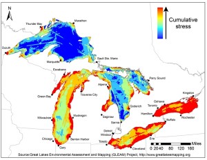
As the U.S. government builds on its $1 billion investment to clean up the Great Lakes, maps like these could help guide new remediation efforts. The maps show where environmental stress is greatest and where combinations of environmental factors — pollution, invasive species and climate change — are having their greatest impacts.
Source: Great Lakes Environmental Assessment and Mapping (GLEAM) Project
The Great Lakes area is home to more than 30 million people in the United States and Canada, and the lakes contain 20% of the world’s fresh surface water. However, the lakes experience significant water quality threats, including urban, industrial, and agricultural runoff, and restoration of the lakes is the basis for the Great Lakes Initiative. Now, an international research consortium, the Great Lakes Environmental Assessment and Mapping (GLEAM) project, is aiding these efforts by mapping areas where stress is most acute to help resource managers determine where to focus their efforts. The map also cross-compares environmental stresses and ecological services in the five Great Lakes. By overlaying the two, the maps show a high number of threats in areas where services are the highest.
The maps examine 34 stressors across nearly 1450 km (900 mi), showing impacts at the scale of 0.8 km (0.5 mi). One of the major categories of stressors examined was nonpoint source pollution. Results of the study are available in an article released Jan. 2 in the Proceedings of the National Academy of Science, and a website is available to provide the information to the public and decision-makers. Read more.


